There are pre-made Geoguessr decks for Anki. However, I wouldn't recommend using them. In my experience, a fundamental part of spaced repetition's efficacy is in creating the flashcards yourself.
For example I have a random location flashcard section where I will screenshot a location which is very unique looking, and I missed in game. When I later review my deck I'm way more likely to properly recall it because I remember the context of making the card. And when that location shows up in game, I will 100% remember it, which has won me several games.
If there's interest I can write a post about this.
> In my experience, a fundamental part of spaced repetition's efficacy is in creating the flashcards yourself.
+1 to this, have found the same when going through the Genki Japanese-language textbook.
I'm assuming you're finding your workflow is just a little too annoying with Anki? I haven't yet strayed from it, but may check out your Obsidian setup.
I do everything from Obsidian now. Anki was very much outside my main flow, and the plugin I linked above works so well for me that I've never looked back.
I did write a tool to convert Anki decks to my own format. I haven’t used it much but it's nice to have.
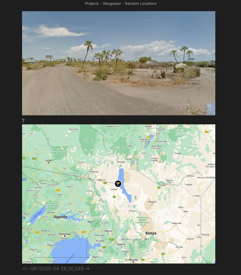
The top image is a screenshot from a game, and the bottom image is another screenshot from the game when it showed me the proper location. All I need to do is separate them with a question mark, and the plugin recognizes them as the Q + A sides of a flashcard.
Notice the data at the bottom: <!--SR:!2025-04-28,30,245-->
That is all the plugin needs to know when to reintroduce cards into your deck review.
That image is a good example because it looks nothing like the vast majority of Google Street View coverage in the rest of Kenya. Very people people would guess Kenya on that image, unless they have already seen this rare coverage, so when I memorize locations like this and get lucky by having them show up in game, I can often outright win the game with a close guess.
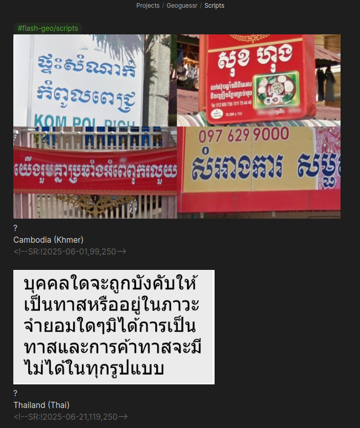
I also do flashcards that aren't strictly locations I've found but are still highly useful. One example is different scripts:
Both Cambodia and Thailand have Google Street View coverage, and given their geographical proximity it can be easy to confuse them. One trick to telling them apart is their language. They're quite different. Of course I can't read the languages but I only need to identify which is which. This is a great starting point at the easier levels.
The reason the pros seem magical is because they're tapping into much less obvious information, such as the camera quality, camera blur, height of camera, copyright year, the Google Street View car itself, and many other 'metas.' It gets to the point where a small smudge on the camera is enough information to pinpoint a specific road in Siberia (not an exaggeration). They memorize all of that.
When possible I make the images for the cards myself, but there are also excellent sources that I pull from (especially for the non-location specific cards), such as Plonkit:
Fascinating - I just got a little lost thinking about how and why you selected this exact image. If you were able to select a single image containing the maximum aggregate count of unique features for any given location and describe them textually, that would make a very useful training data set... for competitive geoguessr and neural networks alike!
I have had so many ideas related to this. Particularly around automation.
Because the way the community arrives at meta knowledge and its geographical distribution is very informal. There are quite a few false metas out there, or the commonly understood range of the meta is inaccurate.
What needs to happen is automated image recognition and mapping of the metas. I started building an open source tool that allows for people to do this manually, but it's quite a difficult project to do myself and I'm not pursuing it anymore. But I would like to see a less manual process emerge.
Do you have a link? I'm curious what your approach to mapping the metas is... I guess somehow identify features and their frequency of appearing in images, then clustering them?
Small question - have you ever used Anki, and/or considered using it instead of this? I am a long-time user of Anki but also started using Obsidian over the last few years, wondering if you ever considered an Obsidian-to-Anki solution or something (don't know if one even exists).
I used Anki for years, not for Geoguessr, but I've been a fan of spaced repetition for a long time.
It worked well and has a great community, but I found the process for creating cards was outside my main note taking flow, and when I became more and more integrated into Obsidian I eventually investigated how to switch. As soon as I did, I've never needed Anki, although there have been a few times I wished I could use their pre-made decks.
I know there are integrations that go both ways. I built a custom tool to take Anki decks and modify them to work with my Obsidian Spaced Repetition plugin. I don't have a need to go the other way at the moment but I've seen other tools that do that.